What is the Devil's Dyke?
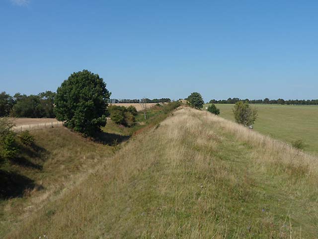
The above image is the Devil's Dyke from near where it crosses the railway line, in 2019
© Nigel Strudwick
The Devil's Dyke in Cambridgeshire and Suffolk is sometimes confused with the better known and similarly named area on the South Downs, near Brighton in Sussex. The big difference is that our Devil's Dyke really is a dyke, an earthwork, while that in Sussex is a natural valley in the chalk.
Probably the most helpful and detailed information available comes from the Inventory of the Historical Monuments in the County of Cambridgeshire, Volume 2, available online by clicking on the link.
The following summary is taken from both Wikipedia and (more) from the web site of the Devil's Dyke Restoration Project (original URL now dead, archived at www.archive.org), in particular their History & Archaeology page. Full credit is made and their copyright acknowledged. Please note that as of August 2019, these last two links not longer appear to be working.
"Devil's Dyke is the last in a series of defensive linear earthworks that stretch south-west, including Fleam Dyke, Brent Ditch and Bran Ditch. These ditches controlled both the ancient Icknield Way and the Roman Roads (e.g. the modern A11) that passed through them and would have posed formidable obstacles. Devil's Dyke is the biggest and best preserved of these, and was constructed to control trade and access as well as being a military or defensive barrier.
Stretching across the open chalk lands between the impassable fenland to the north and the thickly wooded land to the south, it would have formed an effective barrier. Such massive earthworks were not uncommon at the time, as although they were not much of an obstacle to individuals, they would have hindered the movement of large numbers of people, animals and vehicles. The ditch may well have been filled with thorny bushes to act as further defence, and it is possible that the monument may have been built over an earlier prehistoric dyke on a similar alignment.
It is not known who built the Dyke. It lies on the border of the Anglo-Saxon kingdoms of East Anglia and Mercia and given the ditch is on the west side, it was built by the East Anglians against their Mercian neighbours. The Anglo-Saxon Chronicle and other sources record the frequently tense relations between the two kingdoms, and it is likely that this provoked the need to strengthen the border and control access.
There have been several archaeological excavations through the Dyke in the 20th century. In 1973, during the construction of the A14, an archaeological section was excavated and this helped to reveal how the Dyke may have been constructed. It showed that the first stage was a marker bank using topsoil from the immediate area. Material was then quarried from the ditch and was hoisted to the top of the bank in great tips on earth hauling ramps. Gangs of workers were responsible for different sections. However, it is thought that the defences went out of use after only a few years but it did confirm a construction date in the 5th or 6th century AD.
It is common for such monuments to be linked to supernatural entities. Devil's Dyke or Ditch is a post-mediaeval name, probably deriving from a belief that such landforms must be of supernatural origin, and one local legend is that the Devil came uninvited to a wedding at Reach church and was chased away by the guests. In anger the devil ran away and formed the groove of the Dyke with his fiery tail. However, during the mediaeval period it was regularly known as 'St Edmunds Dyke', because it marked the limit of the jurisdiction of the abbots of Bury St. Edmunds. There are also mediaeval references to the 'Great Ditch'. During the 11th century siege of Ely by William the Conqueror, it is referred to as 'Reach Dyke'." © Devil's Dyke Restoration Trust.
There is also a lot of information here about the flora and fauna of the Dyke.